| Amersfoort, June 1995 This
summer I had the time and opportunity to fulfill
my American dream, taking a fully loaded bike
tour through the western region of the United
States. At the time I didn't yet have access to
the Internet, so I planned my route
conventionally by reading outdoor magazines,
borrowed books and an old Rand McNally Atlas.
My first thought was to start in Denver and to
finish in L.A. Taking into account flight
availability and wind direction, I finally
changed my plans and decided to start in L.A. and
cycle to Denver. Another advantage was that I
didn't need to worry about packing my luggage,
because I could conveniently leave my suitcase
and bike box at my cousin's place in L.A.
This decided, I managed to send an Email to
my cousin, using a prehistoric modem (1200 bps)
and a local BBS. I asked for weather information
and maps, which I was happy to find a week later
in my (snail)mailbox! I booked a flight to arrive
on the 4th of July, Independence Day in the U.S.
Tuesday July 4, arrival in Los Angeles
My bike was packed in a huge cardboard box
that was provided by KLM (Royal Dutch Airlines).
I only had to twist the handlebars 90 degrees,
remove the pedals and lower the saddle. No wheels
needed to be removed. I protected my bike with
empty panniers and my foam sleeping pad, and tied
the box firmly using two plastic belts and extra
tape. I've used this box already twice, but its
condition was good enough for yet another trip.
The rest of my gear, plus presents for family and
friends in LA, were packed into one suitcase. I
didn't have to worry about weight limitations: 32
kg is a lot!
After more than 10 hours in flight and a safe
landing in LAX, everything seemed to run smoothly
until I attempt to pass immigration. The official
was very suspicious: "What are you doing
here, and why?" Obviously, they don't
believe that I'm from Holland, but rather an
illegal immigrant from the Far East. "What's
your profession? Who's paying your trip?"
followed by more silly questions. What the @#^/!!!
That's none of their business! Finally I had to
wait one hour for a secondary interrogation.
There goes my American bike dream up in smoke, I
thought desperately, expecting to be sent back
home within a few hours...
Another interrogation followed. I had to prove
I'd really come from Holland, so I showed them
some Dutch chocolate... Now they wanted to see my
credit card. After showing it, they finally let
me go. Luckily my aunt and cousin were still
waiting in the arrival hall.
The temperature outside was pleasant compared
to Holland (25 C). Not bothered by a jet lag, I
stayed up late that evening and joined my cousin
to watch the Independence Day fireworks at Rose
bowl stadium. We had a good view from the so-called
Suicide Bridge. Driving through the streets of
Pasadena, it felt as if I never had left L.A.....
The next few days I spent inspecting and
testing my bike. Although the cardboard bike box
already showed some suspiciouslooking holes, my
bike was still in good condition. The
temperatures had risen to past 30 C. Because of
the heat and L.A.'s notorious smog, it was hard
to cycle around for pleasure. Instead we made
getaway plans for the weekend. My aunt and cousin
were willing to bring me by car to Flagstaff,
Arizona, great! I didn't have to worry anymore
about how to bike across the hot Mojave desert (where
temperatures can be greater than 45C).
Flagstaff was a good starting point for my
trip. The city is build on the high Colorado
plateau (7,000 ft, about 2,000 m) in the vicinity
of the Grand Canyon. The plan was to cycle from
Flagstaff via the Grand Canyon to Utah, while
visiting Zion, Bryce and Arches National Parks
along the way. Then I'd cycle eastward through
the Rockies, ending up in Denver. I'd then take
the bus, train or plane back to Los Angeles.
DenverLA by Greyhound bus (one way) costs about
$100 and 24 hours driving! Amtrak (by train)
charges $160 for one way ticket, just as
expensive as a round trip ($168) and maybe not
much cheaper than flying. Well, I'd decide in
Denver.
At the American Automobile
Association (AAA) office, members can obtain a
lot useful maps and guides for free. I got a very
good road map titled "the guide to Indian
Country", which covered parts of Arizona,
Utah and Colorado. A small problem was the
transportation of the bike on the car. A bike
rack was the solution: it had to be fixed on top
of the trunk with nylon straps. I didn't trust
it; it didn't look very safe. My suspicions were
confirmed during a test drive on a bumpy road,
when suddenly my bike jumped into the air! It
turned out that the straps were not tied properly....

Saturday July 8, Los Angeles
Flagstaff, Arizona
Early on the road, we headed for our first
stop, Laughlin, Nevada, a gambling town. After
passing the San Gabriel mountains we'd finally
left the LA smog behind. At Barstow, in the
middle of the desert, we stopped to tank for gas.
When leaving the comfortable air-conditioned car,
it felt like stepping into an oven: outside it
was 115 F (45 C) in the shade! In Laughlin, a
booming gambling town on the borders of the
Colorado river in the middle of the desert, it
was also pretty hot. What am I up to? Biking in
such temperatures isn't fun anymore! We'd made a
longer stop here to check out the casinos. After
a few hours and losing lots of quarters, we
headed for Arizona. Soon after Kingman the
landscape gradually changed from desolate desert
into hilly, friendly green pineforested terrain.
The weather also changed into occasionally heavy
but refreshing thunderstorms. In the late
afternoon we'd arrived in Flagstaff, where the
surrounding mountains were still covered with
patches of snow! Thanks to higher elevations the
temperature was much cooler over here than in the
desert. The green landscape reminded me of
Germany's Black Forest or the Vosges in France.
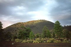
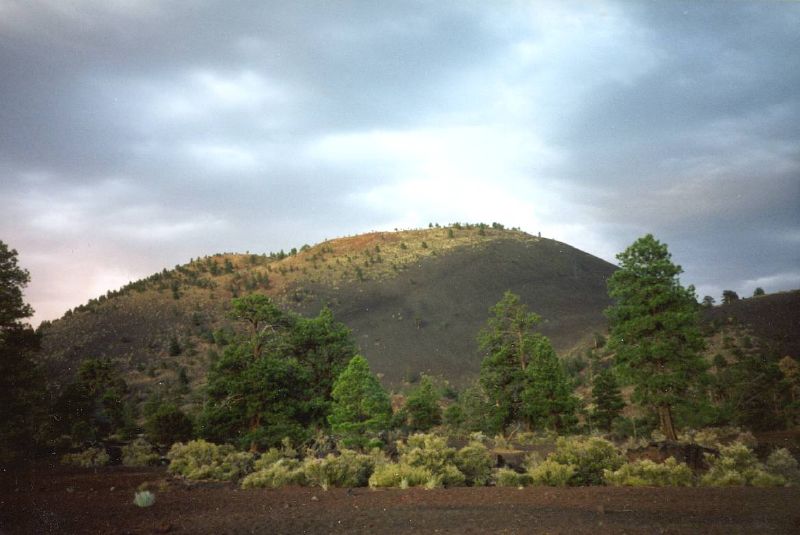
After checking into a motel, we visited Sunset
crater, a nearby old volcano. Walking
through the black lava fields, it felt like a
forest fire destroyed the whole area. Too bad we
were not allowed to hike on top of the crater,
but besides, the sun was already set and it was
getting dark. The motel room had two enormous
queen size beds with a lot of pillows. I could
park my bike inside the room! On a cable channel
a very long report of the Tour de France was
broadcasted. It's again Indurain, who humiliated
all his competitors. It amazed me he didn't wait
for next day's long time trial, but already
attacked in the stage through the Ardennes (what
later turned out to be one of the most exciting
stages of the Tour).
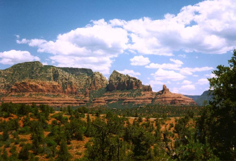
Sunday July 9, trip to Sedona
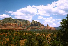 The radio was playing Lou Reed's
"Sunday Morning" while we were driving
down the scenic road to Sedona, just 20 miles
south of Flagstaff. The narrow, winding road
followed the gorgeous gorge of Oak Creek Canyon.
Marvelous and spectacular red rocks protruded
above dark pine forests. Too bad I left my bike
in Flagstaff! The radio was playing Lou Reed's
"Sunday Morning" while we were driving
down the scenic road to Sedona, just 20 miles
south of Flagstaff. The narrow, winding road
followed the gorgeous gorge of Oak Creek Canyon.
Marvelous and spectacular red rocks protruded
above dark pine forests. Too bad I left my bike
in Flagstaff!
After visiting the beautifully located church
we checked out the tourist center of Sedona to
buy souvenirs and had some lunch. In the
afternoon we took a small hike in the rugged back
country. It was almost like a small version of
the Italian Dolomites, but with red sandstone
instead of white limestone cliffs. After
returning to Flagstaff, I said goodbye to my
aunt and cousin, who returned to Laughlin, where
the hotels were much cheaper (only to blow out
their extra cash at a casino in Nevada on the way
back home). I loaded my bike and pedaled to the
next campground just outside of town.
 Monday, July 10, Flagstaff
Grand Canyon (138 km) Monday, July 10, Flagstaff
Grand Canyon (138 km)
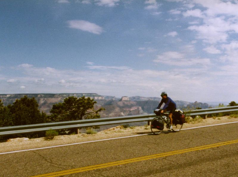
The first stage took me from Flagstaff to
Grand Canyon National Park. With a comfortable
tail wind I pedaled through a landscape of
rolling hills covered with meadows and dark pine
forests. It reminded me a lot of the eastern part
of Norway and Sweden. The snowcapped San
Francisco Peaks accompanied me during much of the
route.
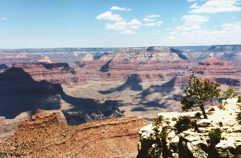
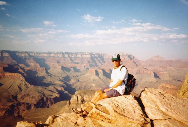
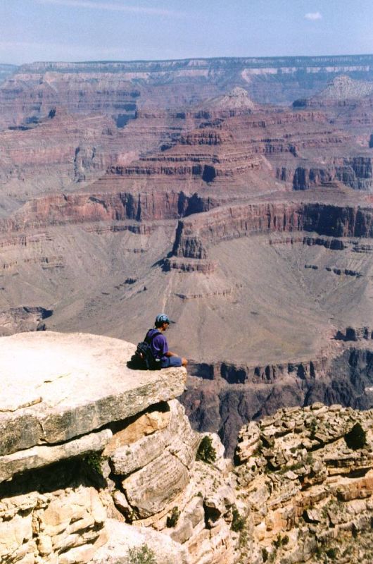
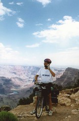
When I got closer to the National Park, the
landscape didn't change dramatically. Even after
entering the park it was still the same, I'd even
call it flat. I could have been driving through
the forests around my hometown instead. But then,
after a sign directing me to Mather viewpoint,
the secret finally revealed: a majestic wide
colorful gap appeared in the earth. Although I
had already seen a lot of pictures in books and
magazines, slides from family, TV programs etc.,
the real thing impressed me enormously, yes it
was VERY impressive indeed.
 
It was still early in the afternoon when I
looked around for a nice campground. Too bad,
free camping wasn't allowed in the park, so I
headed towards Grand Canyon Village. As I could
expect, the campground was already full, but I
didn't want to turn back and look for a
campground outside of the park. I sneaked past
the gate, and looked for a spot to share. Then I
encountered a guy who 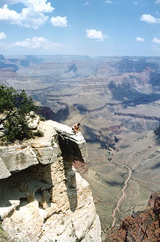 happened also to be a
Dutchman traveling by bike! His name is Erwin,
and he was taking a cross country trip. Started
just a week ago in L.A, he encountered a lot of
problems attempting to cross the California
desert. Sometimes he had to hitch a ride from a
pickup truck. He was carrying plenty of water,
but it was boiling in the bottles and he nearly
suffered from dehydration. This heard I felt it
was a wise decision not to bike through the
intense heat of the desert in the middle of the
summer. Erwin shared a spot with two Danish
bicyclists, who were also traveling crosscountry,
but from the east to the west coast. I remembered
seeing them while I was resting in the shade a
few hours ago, when they were heading south. happened also to be a
Dutchman traveling by bike! His name is Erwin,
and he was taking a cross country trip. Started
just a week ago in L.A, he encountered a lot of
problems attempting to cross the California
desert. Sometimes he had to hitch a ride from a
pickup truck. He was carrying plenty of water,
but it was boiling in the bottles and he nearly
suffered from dehydration. This heard I felt it
was a wise decision not to bike through the
intense heat of the desert in the middle of the
summer. Erwin shared a spot with two Danish
bicyclists, who were also traveling crosscountry,
but from the east to the west coast. I remembered
seeing them while I was resting in the shade a
few hours ago, when they were heading south.
Of course Erwin didn't mind sharing the huge
campsite. After pitching my tent and having a
refreshing shower, we'd decided to make a guided
evening walk with a ranger. We followed a small
part of the South Kaibab trail, a hike below the
rim. A hike in the canyon is like the opposite of
climbing a mountain: after a relatively easy
descent, followed by a steep and strenuous climb
back. Going all the way down to the river with an
elevation difference of 7,000 ft. was not
recommended in one day! On the descent we passed
several climatic levels: from a cool temperate
climate like Canada on top of the plateau, to a
hot Mexican like desert environment on the bottom
of the canyon. But on this leisurely evening walk
we didn't go so far down below. The views and
scenery were truly amazing, I desperately
wondered how to take pictures with my compact
camera, knowing that the result would never look
as real as it should be....
At the end of the day, around sunset, the
views were not as bright as early in the
afternoon. According to the ranger this haziness
was caused by the smog from Southern California...
Darn, the pollution of LA was following me even
here, hundreds of miles inland!! :(
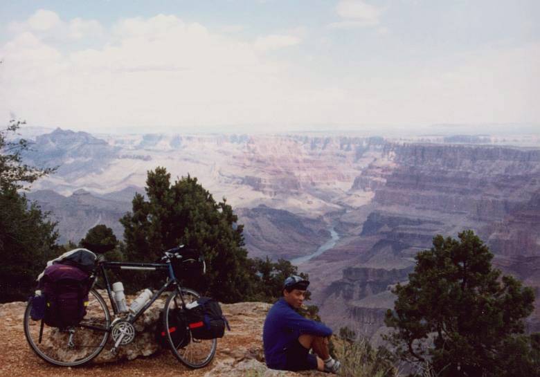
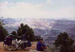
Tuesday July 11, Grand Canyon Village
The paved road along the west rim was only
accessible by bus or on bike. We decided to leave
our bikes at the campground and took the free
shuttle bus to the west rim trail head. It's
amazing that we hardly met any other hikers on
this trail, except at the outlooks close to the
bus stops. After a 10 miles long and wonderful
hike, with lots of photogenic stops, we took the
shuttle back to the campground. Just as we
arrived in the self service restaurant to have
some lunch, a heavy thunderstorm broke. The heat
wave was moving eastward, followed by the monsoon
from Mexico. Anyway, the cool temperatures were
better for cycling and besides, we'd now a nice
tail wind when heading east!
Wednesday, July 12, Grand Canyon Tuba
City (85 miles/137 km)
  Because Erwin and I were
planning to cycle the same direction, we decided
to ride together for a while. Erwin was used to
get up very early, too early for my standards.
After convincing me we'd better to avoid the heat
of the afternoon (or in these days, be prepared
for the afternoon's thunderstorms) I finally
agreed getting up early. Around seven we left the
campground (without paying since we shared a site
with someone else) and pedaled our bikes over the
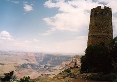
East Rim Drive to Desert View. We combined a
visit to the old ruins of the Pueblo Indian with
fixing a flat tire. Near the Watchtower at Desert
View, we threw a final glance at the Grand Canyon. Because Erwin and I were
planning to cycle the same direction, we decided
to ride together for a while. Erwin was used to
get up very early, too early for my standards.
After convincing me we'd better to avoid the heat
of the afternoon (or in these days, be prepared
for the afternoon's thunderstorms) I finally
agreed getting up early. Around seven we left the
campground (without paying since we shared a site
with someone else) and pedaled our bikes over the
East Rim Drive to Desert View. We combined a
visit to the old ruins of the Pueblo Indian with
fixing a flat tire. Near the Watchtower at Desert
View, we threw a final glance at the Grand Canyon.
Erwin was sponsored by a cellular phone
company. In exchange for wearing Tshirts and
making some pictures for advertising, he could
use the cellular phone without any charge.
Unfortunately, the phone didn't work in this
remote part of the country! That's some good
advertising!
After leaving the National Park, a long
descent followed. Until Cameron the route was
still very scenic, passing the rough Little
Colorado gorge and splendid views over the
badlands of Painted Desert in the distance. After
Cameron we met a lot of traffic on highway 89.
Especially we'd to watch out for exceptionally
heavy loaded trucks. Before the heavy
thunderstorms started again, we'd found some
shelter in one of the many Indian stands along
the road. After hours of waiting, it stopped
raining. My initial plan was to travel further
north on the "89" to Utah, but now it
was already too late. Besides, it wasn't fun to
bike on this busy highway with still so many
miles to go. I decided to join Erwin, whose plan
was heading east and finds a place to stay in
Tuba City, 20 more miles to go. After a steep
hill we entered the town, and since there was no
campground we checked into a youth hostel. Since
we were no members, we paid a lot for one room, $40.
Unfortunately we also missed the broadcasting of
the first mountain stage of the Tour de France on
TV.
Thursday July 13, Tuba City Marsh
pass (87 mi/140 km)
That day I definitely decided not to return to
the "89" that would bring me into Utah.
Instead I joined Erwin a couple of days more. The
plan was to follow the "160" to
Monument Valley. From there I planned to cycle
north to Moab and Colorado. I could still visit
Zion and Bryce Canyon on my way back from Denver
to LA.
The route between Tuba City and Kayenta was
less interesting than the miles we had left
behind. This area was very inhabited, no
villages, just some trailers where Native Indians
lived. The map showed a village that only
appeared to be an abandoned trading post. Luckily
there was an icecream car parked along the
highway! Thirsty of the heat the snow cones
tasted very good. After 55 miles we stopped for a
lunch break at a small cafe at the turnoff to
Navajo National Monument. A sudden heavy
thunderstorm kept us waiting in the cafe for
hours and hours. We were now in the Navajo Indian
Reservation. Unlike the rest of the State
Arizona, the Navajo Nation observed daylight
saving time, which meant another hour went by
without notice! At the crossroad a narrow road
was leading to the cliff dwellings of Navajo
National Monument. As soon the skies cleared up,
I jumped on my bike and visited the cliff
dwellings, 9 miles further uphill. Erwin didn't
want to join me climbing the 9 miles. He'd
already gone to Mesa Verde National Park in
Colorado some time ago, where more beautiful
examples can be visited.
The climb wasn't too hard at all, but the
ruins were hardly visible from the viewpoint and
only accessible by a guided hike over a very
strenuous trail. It was already past six and the
guides already went home. The scenery along the
road and the canyon itself made the ride
worthwhile though. Back to the cafe we decided
what to do next. Staying here in a trailer park
didn't seem to be very attractive, there was mud
everywhere. Seven miles further, on the Marsh
pass (6,750 feet), there seemed to be a motel. In
the meantime, it started raining again. Soaking
wet, we arrived at the motel. "A room costs
normally $90, but all right, for some poor wet
bikers, we only charge $70" told the
receptionist. As soon as the thunderstorms went
by, we asked if it was allowed to pitch our tents
on the nice green lawn next to the motel. Luckily
they didn't mind, so we had again a free campsite.
 Friday July 14, Marsh pass
Monument Valley (63 mi/102 km) Friday July 14, Marsh pass
Monument Valley (63 mi/102 km)
A quick descent to Kayenta. In the distance a
small moving spot turned out to be another cycle
tourist! A guy from Switzerland, cycling from
Grand Junction to San Francisco. He stayed last
night in Kayenta's Hilton Hotel, so he started
not long ago, just like us. From Grand Junction
to Moab he encountered some problems, a long dirt
road without any villages in between. Since I had
also the intention to cycle from Moab to Grand
Junction, I've been warned what is to come...
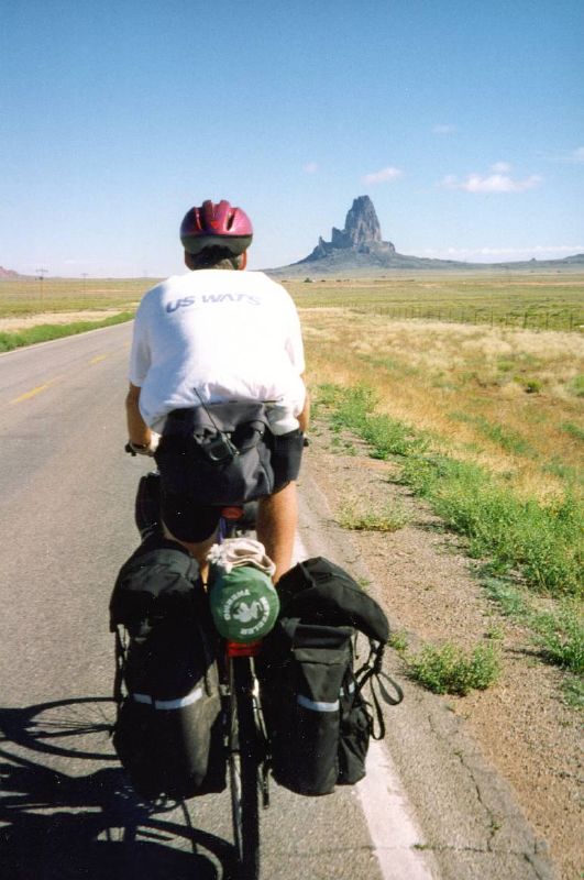
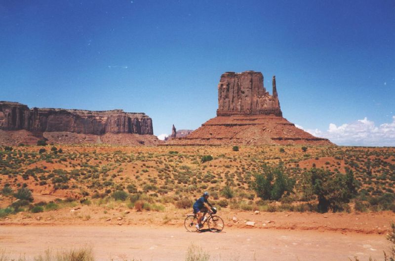
From Kayenta we took the turnoff to the narrow
US 163. Along the road several billboards were
announcing the beauty of the scenery ahead of us.
And indeed, a very brilliant route was leading to
Monument Valley. This area of lonesome rock
formations is world famous as scenery in movie
pictures and cigarette commercials. The weather
was also gorgeous: cool temperatures, bright blue
skies and a little tail wind, just perfect. At a
stand a native American was selling Beef Jerky.
Dried and salted meat, made of the best parts of
beef. It tasted delicious.
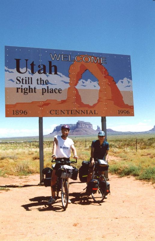
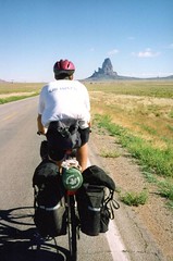
On the border of northern Arizona and southern
Utah, we stopped at the huge welcome sign. A
French photographer approached us and asked if he
could take some pictures for a photo reportage
about the "American Dream". Of course
we didn't mind since this setting would perfectly
fit in our American bike dream.
  Mitten view campground at
Monument Valley Navajo Tribal Park is situated at
one of the most scenic spots I've ever been. From
the rim of the plateau we'd a wonderful view over
the valley. We would like to pitch our tents just
on the edge of the rim. Since all the scenic
spots were booked, we asked to share the site
with a friendly Italian family. Being still early
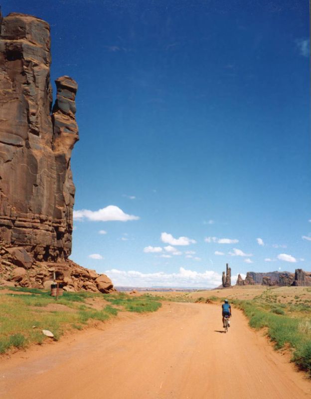
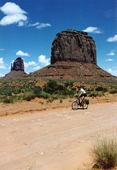
in the afternoon, we still had time to ride the
valley drive: a 17 mile unpaved loop road winding
down through the park. I had some problems biking
the steep downhill grade from the campsite into
the valley. My Giant Expedition touring bike was
not very convenient for this offroad work.
Erwin's Specialized MTB was apparently better and
faster in this terrain. Anyway, it was a great
ride pedaling along the red brown mesa's and
buttes with fancy names like elephant, camel,
three sisters and totem pole. The landscape of
Monument Valley is formed by erosion processes.
What once (millions of years ago) was a solid
massive plateau, now only the resistant sandstone
rock formations remained, while the weaker
sediments were flushed away. Mitten view campground at
Monument Valley Navajo Tribal Park is situated at
one of the most scenic spots I've ever been. From
the rim of the plateau we'd a wonderful view over
the valley. We would like to pitch our tents just
on the edge of the rim. Since all the scenic
spots were booked, we asked to share the site
with a friendly Italian family. Being still early
in the afternoon, we still had time to ride the
valley drive: a 17 mile unpaved loop road winding
down through the park. I had some problems biking
the steep downhill grade from the campsite into
the valley. My Giant Expedition touring bike was
not very convenient for this offroad work.
Erwin's Specialized MTB was apparently better and
faster in this terrain. Anyway, it was a great
ride pedaling along the red brown mesa's and
buttes with fancy names like elephant, camel,
three sisters and totem pole. The landscape of
Monument Valley is formed by erosion processes.
What once (millions of years ago) was a solid
massive plateau, now only the resistant sandstone
rock formations remained, while the weaker
sediments were flushed away.
 
|