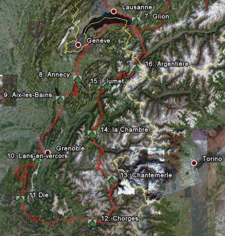
Part 2: French Alps
 Day 10, Glion (hiking trip)
Paul invites me for a little hike in the vicinity. First we catch a tourist train heading to Rocher de Naye. Along the way we get off the train and walk under the grate of the Dent de Jaman to the pass with the same name. There's a little restaurant on the pass where we make a lunch stop. Speciality is the so called Käseschnitte, a Sandwich abundantly supplied with melted cheese. After lunch we walk down the pass on a hiking trail, the same trail which I intended to cycle from Gstaad. Luckily I didn't because the few bikers we encounter on mountain bikes don't look very happy. The trail is very rugged with loose rocks and certainly not suited for a loaded recumbent. The landscape is very scenic though. Paul suggests we take some shortcuts straight through the meadows, but since I'm on my Teva sandals I prefer to stick to the road.
In the hamlet of Les Cases the road becomes paved again. Here we take a break and drink some apple juice in a cafe. Unfortunately the cafe owner is not in the mood to perform one of his famous concerts. In another hamlet of Allieres we catch a train back to Montreux. In the village Les Avants we get out for a walk down the canyon of the Gorge du Chauderon, where we pick up a hiking trail all the way down to Montreux. Down in the canyon it's dark, hot and humid, seems like a jungle. In Montreux we catch a train back to Glion. In the evening we enjoy a delicious Indonesian home made dish, Nasi goreng.
Day 11 (rest day)
My initial plan for today was to head into France and
find a nice spot to watch the Tour de France. However,
since it's pouring down I decide to give the Wizard an
extra rest day.
Not a bad idea since my muscles still feel a bit sore
after the long hiking trip and now I'm able to watch the
Tour on TV. In the legendary mountain stage to
Albertville I watch Pantani's successful attack on the
yellow jersey from Ullrich under terrible weather
conditions.
Day 12 Glion-Annecy (130 km)
Today it's really time to leave because my hosts are also ready to go. Paul is making a hiking trip in the Black Forest while his wife is visiting relatives in the Netherlands. I'm heading for the French Alps to witness a Tour stage live. It's still drizzling a bit when I cautiously head down to Montreux. Along the borders of the French side of the lake I approach (am close to?) the suburbs of Geneva and on a traffic free D15 that runs along the foothills of Mont Salève, I reach Annecy without any hard effort. This picturesque town is crowded with tourists. I decide to cycle the climb to the Crêt de Chatillon, a mountain of the 1st category. Here I hope to find a camping spot from where I can watch the Tour de France. Tomorrow the Tour will go through Annecy and everywhere are signs marking the route. At the foot of the climb I find a camping Municipal where I decide to pitch my tent. A sign says "Complet" (full) but for a person on a bike there's always a camping site available. My neighbour is a French guy who is also travelling by bike, doing his own Tour de France. He has done all the famous Pyrenees climbs with success and is now ready for the Alps.
 Pantani &co.
Day 13 Annecy-Aix-les-Bains (65 km)
Crêt de Châtillon (1640 m) Length 17.5 km;
elevation 1195 m, grade 6.5% (max. 10%) index 8,2
The next morning we decide to cycle up the climb to the
Crêt de Châtillon together and watch the Tour somewhere
along the road. The French guy leaves all his equipment
behind at the campsite, planning to stay there another
few days. I'm planning to travel further and am carrying
everything with me. The road is closed for all traffic
after noon, so we've plenty of time to make it to the top.
The first part of the 17 km long climb is heavily
forested, a bit up and down, not too difficult. After a
while the road steadily rises but never gets too steep. I
manage to keep my speed around 9 km/hr and am still able
to follow the French guy. Sometimes we even catch up to
other cyclists. The audience cheers as we cycle by; my
recumbent attracts a lot of attention. On top of the
mountain the green Alpine meadows are crowded with people.
We enjoy the excellent views and the sun is trying to
break through the clouds. From the radio I gather that
the riders are on strike. Several teams have been visited
by the police, searching for drugs. Some managers,
members of the medical staff and even riders have been
arrested.
Finally the pack is moving, but very, very slowly.
Later, much later, when I start to get bored by the views
of Mont Blanc (the commercial caravan has passed already
hours ago), the Tour riders finally reach the top of the
mountain. After 5 minutes the whole pack is gone and the
audience can start the descent. It's fun that all the
cyclists can start the descent first. In a huge pack we
follow the Tour de France riders, just like being a
participant, cool!
A few minutes later we even reach the tail of the
following Tour caravan.
In Lecheraines I turn right to Aix-les-Bains, the Tour is heading straight to the Mont Revard, before finishing in Aix-les-Bains. When I reach Aix the riders are still climbing the pass and I start looking for a campground. It's a nice coincidence all campgrounds are on the same boulevard near the lake where the finish line is drawn. I've only to follow the track and the crowds to find the finish line. It's 7.30 PM when the complete pack (without any competition) arrives, the TVM team at the head. That the results of the stage have been declared invalid doesn't bother me, it was a once in a lifetime experience and worth watching it!
 Grands Goulets, Vercors
Day 14 Aix-les Bains-Lans-en-Vercors (110 km)
col de Couz (626m), col de la Placette (587m), Gorges d'Engins (1004 m)
The Tour de France departs today from Aix-les-Bains. Since I'm not very eager to watch the departure I leave all the crowds behind me and head south on a busy highway along the lake. The busy two lane highway suddenly transforms into a 4 lane motorway, forbidden to cyclists. I have to turn around and go back, finding an alternative route to Chambery through an industrial district. All of a sudden I find myself riding on a bike path, which seems to run from the Lac du Bourget to Chambery. The road signs for cyclists are again very poor, when I enter Chambery. I make a detour, ending a few kilometers later at the same point where I started. I decide to leave this place as quickly as possible. On a national highway (not too busy though) I cycle along the Chartreuse plateau. After two minor passes (col de Couz and col de la Placette) I reach the suburbs of Grenoble. Near a hydroelectric power station I cross the Isère river. I ask a local guy on a racing bike for directions and find the bicycle track beside the river, leading all the way to Sassenage. In Sassenage I stop for a lunch break before starting the not so difficult climb to the Vercors plateau. Because of the heat (32 C) the first 5 k of the climb cause me a lot of trouble. I'm not in a great shape and with a headache I need to stop at the first hamlet, looking for some shade and water. It seems clear my body can't cope with the great changes in temperature anymore. Although the hardest part of the climb is now over, I don't feel very well. Not far from Lans-en-Vercors I find a nice campsite in Le Peuil, a small hamlet.
 Day 15, round trip Vercors
Col de Carri (1202 m) h:528m l:11,7 km 4.5%
avg., 9% max.
Gorges de la Bourne (931m)
h:701m, l:20 km, 3,5% avg.
It keeps on raining all night long. In the morning the surrounding mountain ranges are covered in clouds and the temperature has dropped to 15 C. I decide to stay one night extra at this campsite to make a round trip in the Vercors. After Villard-de-Lans I ride through the scenic Gorges de la Bourne, climbing to the village of St. Julien-en-Vercors in the mist. A few times I have to seek shelter from the rain. I visit the Grands Goulets, a narrow gorge where the road is like a gallery, even more impressive than the Gorges de la Bourne. I descend the canyon to the point where the gallery ends and then turn back.
Combe Laval, Vercors
I climb the Col de Carri, which is not too bad. After descending to the Col de la Machine I reach the next highlight of the trip: the Combe Laval. A valley in the shape of a horse shoe (cirque) with steep limestone rocks rising high above the valley floor. The weather has improved a bit and I can enjoy the magnificent views over the plains of the Isère and Rhone valleys. In a long descent I lose about 1000 meters in altitude. Below in the valley it's pleasantly warm. In Pont-en-Royans I take a few photos of the picturesque overhanging houses at the Bourne river. Luckily the climb back through the gorge back to the campsite in Lans-en-Vercors is not too difficult.
 Just another Vercors
picture
Just another Vercors
picture
Day 16, Lans-en-Vercors-Die (82 km)
Col de Rousset (1254 m)
I listen frequently to the weather forecasts on my radio. Severe weather is expected, especially in Switzerland, and huge amounts of rain also in the French Alps. I decide to change plans. Instead of descending to Grenoble and heading for Le Bourg d'Oisans, I'll take the Wizard as far south as possible to Provence, hoping for better weather. When I reach the hamlet of Rousset, I have to shelter from the pouring rain. After the rain has gone by I start the not so difficult climb to the col de Rousset. On the pass there's a winter sports resort and a dark tunnel. At the other side of the tunnel it looks like I've entered a completely different world! A gorgeous view of the Provencal Alps is unfolded before my eyes. Skillfully I steer the Wizard through the many hairpins, heading for the flowering fields of lavender. In passing I catch up with a guy on a racing bike who started the descent just before me. In the sunny city of Die there are a few campsites. I opt for the camping municipal, near the centre of the city, and pitch my tent in the shade. After taking a warm shower I discover that a French family has pitched their huge tent in front of mine. I'm pissed off by their antisocial behaviour and annoyed I turn my tent 180 degrees. The view is now reduced to the walls of two caravans, but at least I have some privacy. Because I do not feel very well (probably caused by the flu) I hit the sack very early.
Day 17, Die-Chorges (120 km)
Col de Cabre (1180 m)
After a long sleep I feel fit enough to cycle on, although the flu isn't yet gone completely. However, the weather is comfortably warm, hopefully aiding a quick recovery. In Die I buy a Michelin road map of Provence and decide to head for Gap via the D93 along the Drôme river. It's a major highway according to the map but luckily the traffic isn't too bad. After Luc-en-Diois I pass a narrow gap in the mountains, le Claps. A fantastic sight: huge boulders are spread out everywhere. After seeking shelter from a storm I leave the Drôme valley and start the climb to the Col de Cabre. Luckily climbing is going very well now. After the pass the road gets busier and becomes undulating towards Gap. I'm surprised I'm still feeling very well, so I keep on going and find a quiet campsite past Chorges, close to the Lac de Serre-Ponçon.
Day 18 Chorges-Chantemerle (85 km)
I'm feeling a lot better now. This can't be said of
the weather, which is now quite miserable.
I have to change plans again. Cycling to Briançon over
the col d'Izoard is not very wise considering the weather
and my physical condition. The alternative, the busy
highway N94 through the Durance valley, doesn't seem very
attractive either. Luckily there are some back roads
parallel to the N94 to avoid the heavy traffic. After
Embrun I follow the D-994 on the opposite side of the
river, a very scenic route. The road is constantly going
up and down, now and then revealing nice views of the
valley.
Beyond St. Clément there's no choice but to cycle the
busy highway. Another storm forces me to find some
shelter under a big oak in St-Crépin. A friendly local
shows some compassion and invites me in for a cup of
coffee, an offer I cannot refuse. Despite my broken
French I manage to start a nice conversation with the
residents. The mother of the guy who invited me in offers
me a complete hot meal! A remarkable coincidence is that
my host also studied Geography. With great enthusiasm he
shows me a lot of maps of the region. Places he
recommends are Ailefroide in the heart of the Encrins
mountains and the Vallée de la Clarée just north of
Briançon. Considering the miserable weather maybe nice
destinations for another time?
Time flies by very fast and in the meantime it's dry
again, time to go. The whole family waves me goodbye as I
cycle out of town. Via a back road I head for l'Argentiere,
avoiding the N-94 by taking the D4 in les Vigneaux. When
I pass the hamlet of la Batie, two cars collide. I fear
the presence of the Wizard distracted their attention....
In les Vigneaux I leave the scenic valley of the Gyronde behind and start the difficult climb to Briançon. This crowded city is not what I'm looking for and I head quickly out of town, to find a nice, well equipped campground in Chantemerle.
Day 19, Chantemerle-St. Martin sur la Chambre (93 km)
Col du Lauteret (2058m) h:588m l:14km avg 4.2%
max. 7.5%
Col du Galibier (2646m) h:588m l:7.5km avg. 6.9%
max. 9%
Col de Télégraphe (1566
m) h:169m l:5km avg. 3.4%
The next morning with fresh courage I begin the renowned stage over the famous pass of the Galibier. Luckily I'm climbing this famous Alp from the easiest side. The initial part of the climb via the Col du Lauteret is long and not too steep. With a guy on a mountain bike chasing me I can keep the speed pretty high, 12-14 km/hr. After a short break on the pass I start climbing the Galibier. Zigzagging I cycle to the top, enjoying the views. Now and then a few bike riders catch up with me. It surprises me there are no other people on loaded touring bikes. I stop for a photo at the monument of Henri Desgranges, one kilometer before the pass. The views on the mountainous region are still excellent despite the rainy weather. Climbing seems going well too, a lot better than in the heat.
The last mile of the Galibier is the longest one. After the monument the gradient gets pretty steep but it's not very far to the pass. With an average speed of 11 km/hr I reach the 2646 meters above sea level, the highest point of this trip. On top of the pass is a huge crowd, lots of cars, motorbikes and cyclists coming and going. After the usual photo (unfortunately the development of the last film roll failed) I dress myself properly for the long descent.
The road surface is wet and its condition miserable, the scenery overwhelming. After Plan Lachat the twisting and turning of the road is over and I can loosen the reins. However, as the steepest section is also behind me, it is not possible to go any faster than 70 k per hour.
Slightly overcome by the cold I reach Valloire. The
next pass, Col du Télégraphe, is only 5 k of climbing.
I'm riding now constantly in the mist. For reasons of
security I turn on my rear light. After the misty descent
I reach the valley of the Arc. This valley seems packed
with busy highways and industrial activity, terrible.
Luckily there is a bicycle lane along the motorway, but
it's not what I'd call beautiful. I decide to leave this
awful place as fast as I can. Heading for Albertville
means riding over the Col de la Madeleine. There's no
need to worry about that pass since I conquered the
Galibier successfully. Besides, I've heard from Luddo
that the Madeleine is a piece of cake. The first warning
follows when I leave the Arc valley in La Chambre,
looking for a campground on the foot of the Col. The road
rises up steeply and with the greatest effort I reach the
campground "Le Bois Joli" (The pleasant forest).
This climb is tougher than the last part of the Galibier!
The crowded campground turns out to be not very pleasant
at all. A group of drunk French people manage to disturb
my night's rest. Even my earplugs won't help. After I
shout at them to shut up it gets quiet.
 Earth pyramids
Day 20, St. Martin-Flumet (92 km)
Col de la Madeleine (1995 m) h:1536m l:20km avg. 7.7% max. 10% (index 12)
During my breakfast I see two cycle tourists passing
by, tackling the pass. After I've packed all my stuff I
start the climb as well. The first 10 km are very
strenuous, constantly climbing 10%.
I'd underestimated the climb, this is a lot tougher than
the southern slope of the Galibier, Klausen- and
Sustenpass. The southern slope of the Madeleine is
regarded as one of the toughest climbs in France. However,
I encountered more difficulties with both Swiss passes
because of the heat and the shape I was in. Despite the
hardness of the climb I'm making progress very well. I'm
approaching the two cyclists I saw back at the campground.
Shortly afterwards I catch up with the two, two young
German guys. Just before St. Francois-Longchamp I'm
attacked by a big cloud of flies. The tougher the climb,
the more flies seem to attack me. At a picnic place I
need to stop to shoo the flies away and to have some
lunch. I'm lucky I'd stopped right where there's a
lookout over a geological phenomena called "earth
pyramids". Pillars of sediment that have survived
soil erosion, because of the protection by a stone or
rock. I'm very grateful to the flies who brought me here.
In the meantime the German cyclists catch up with me. I don't have to work hard to 'repair the damage'. They aren't cycling very fast and before Longchamp I leave them behind. After the winter resort the road climbs above the timber line and the pass is visible. From the pass I've a nice view of Mont Blanc. In Albertville, reached after a long descent, a cycling fan is asking me how long it took to conquer the Madeleine. "Two hours and 48 minutes" is my answer. "The riders in the Tour did it in 2 hours less" replies the man, but they needed drugs to reach that result he adds laughing.
My initial plan was to cycle via Beaufort and the Col
des Saisies to Megève. Somewhere I miss the right turn
and head to Ugine on a busy N 212. Cycling back to
Albertville on this four lane highway isn't a good option,
nor climbing a big hill via another back road to Beaufort.
Luckily there's a road adjacent to the highway and past
Ugine the N212 is partially closed to oncoming traffic
due to road constructions through the narrow Gorges de L'Arly.
At the campground of Flumet I meet another cycle tourist.
Since he's carrying well known grey Dutch panniers, I
greet him in Dutch. Unfortunately he doesn't have a clue
what I'm saying since he turns out to be from Germany...
Day 21, Flumet-Argentière (59 km)
Last cycling day in France. I decide to take it easy and recover from all the climbs. The weather has changed and a high pressure system has entered France. It's sunny and dry, temperatures rising steadily. The roads in the Mont Blanc area are congested with car traffic. It's still a long way to go to Megève when I meet the first traffic jam. I manage to steer my recumbent around the cars. Despite the splendid views of the Arve valley, the mountain ranges of the Aravis and Mont Blanc, I don't enjoy the descent to St. Gervais. I need to slalom around the cars frequently, longing to leave this touristic pandemonium behind for some quiet back roads. Finally I find one, a small mountain road from Chedde to Servoz with a constant view of Mont Blanc. After Servoz I descend and return to the traffic jam, heading towards Chamonix.

Chaine des Aravis
Before the next serious pass I find a campground in Argentière early in the afternoon. The campground is crowded with dome tents. The crowds are not unpleasant though, lots of coming and going hikers and climbers. In the evening a pizza van stops at the entrance of the campground, baking delicious pizzas.